Aquifer Science
The Major Aquifers of the EUWCD:
- The Carrizo-Wilcox Aquifer spanning from the northern boundaries of Frio, Atascosa, and Wilson counties to the southern boundaries of the same counties. The Carrizo-Wilcox Aquifer also occurs in the north part of Karnes County.
- The Gulf Coast Aquifer System in Karnes County.
The Minor Aquifers of the EUWCD:
- The Queen City Aquifer in Frio, Atascosa, and Wilson Counties
- The Sparta Aquifer in Frio, Atascosa, and Wilson Counties
- The Yegua Jackson Aquifer in southern Atascosa and Wilson counties and Karnes County.
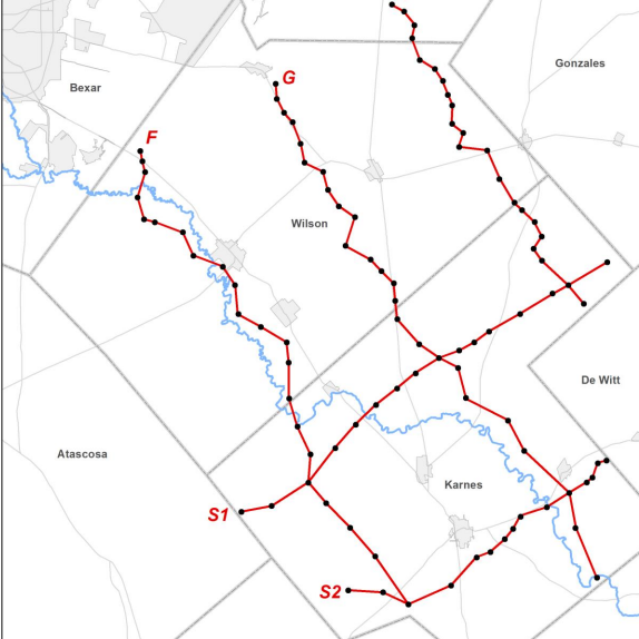
Click on the dots in the map to see water levels near you.

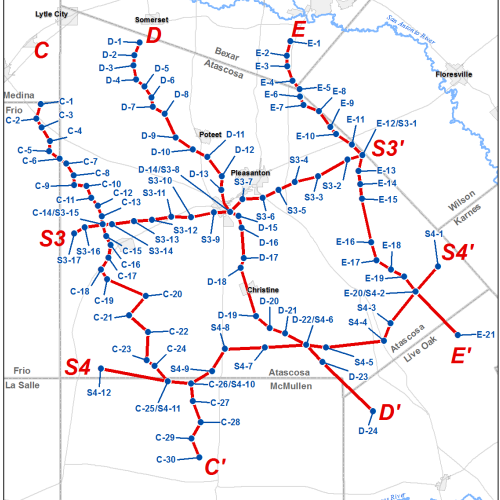
Monitoring Well Program
The Evergreen Underground Water Conservation District (EUWCD) operates an extensive Monitoring Well Program to track the health and availability of groundwater resources across the region. These dedicated wells allow the District to collect long-term data on water levels and aquifer conditions, which supports responsible groundwater management and planning.
Monitoring wells are strategically placed throughout the District in both major and minor aquifers. The major aquifers within the EUWCD include the Carrizo-Wilcox Aquifer, which spans Frio, Atascosa, Wilson, and parts of Karnes County, and the Gulf Coast Aquifer System, located in Karnes County. Minor aquifers include the Queen City, Sparta, and Yegua-Jackson aquifers, which provide water to local users and also serve as critical components of the region’s hydrologic system.
By collecting consistent and reliable data, EUWCD is able to evaluate trends over time, assess the impacts of pumping, support planning for drought conditions, and ensure that Desired Future Conditions (DFCs) are being met. This program also helps to inform policy decisions, permit reviews, and conservation strategies, ensuring that groundwater remains a sustainable resource for future generations.
If you are a well owner interested in participating in the program or allowing access to a well for monitoring purposes, you can learn more by filling out the application below.
Monitor Well Application
Complete this form if you would like to designate an existing well for monitoring purposes and participate in EUWCD’s monitor well program. Learn more about our monitor well program here.

Water Quality Program
Each year, the District collects groundwater samples from at least eight water wells across our service area—typically two wells per county—and submits those samples for chemical analysis focused on constituents of concern. We try to space sampling locations out as evenly as possible across the District so we’re not over-representing one area and missing another. While eight samples is our standard baseline, we can collect additional samples when a landowner has a specific need and the District can use the data based on the well’s location (for example, to fill a gap in coverage or help evaluate a local concern). Results from each year’s sampling are summarized in a water quality results table in our Annual Report to the Board of Directors, along with a clear discussion of whether any potential groundwater contamination or other issues of concern were identified in the analyses.


Image: 2025 water quality sample locations and aquifers.
What are we testing?
Each water quality sample we collect is run through a General Water Quality Test at a San Antonio TCEQ NELAP Accredited Laboratory. This means we’re looking at a broad mix of constituents that help us understand overall groundwater quality—not just one “contaminant.” As shown in the chart on the right, the lab analyzes general chemistry to include: alkalinity, conductivity, total dissolved solids (TDS) and pH. Temperature of the sample is taken at the well site location and again at the lab, the samples are immediately placed on ice once sampled from the wells, so the lab temperatures are not representative of the aquifer temperatures. Key anions tested include: fluoride, chloride, nitrate, and sulfate. Common metals tested include: aluminum, arsenic, calcium, copper, iron, lead, magnesium, manganese, sodium, and zinc.
This gives us a well-rounded snapshot of what’s in the groundwater and helps us spot patterns, changes, or outliers over time and across the District.
Understanding water results (MCL & NSE)
On the chart, MCL stands for Maximum Contaminant Level, which is the “do not exceed” numbers used for drinking water standards set by the EPA—if a result is over the MCL, it’s a sign that the water may need a closer look, follow-up sampling, or treatment depending on the situation.
You’ll also see NSE, which stands for No Standard Established. That doesn’t mean the constituent is “bad” or “good”—it just means there is not a set regulatory limit listed for that constituent, so we interpret it using trends, typical ranges for the area, and the overall chemistry of the sample.

Image: Above is a list of the constituents tested with each water quality sample.
MCL: Maximum Containment Level; NSE: no Standard Established; mg/L: Milligrams per Liter;
Total Dissolved Solids (TDS)
TDS stands for Total Dissolved Solids, and it’s one of the biggest “big picture” numbers people ask about because it’s a simple way to describe how mineralized the water is. TDS includes the natural dissolved salts and minerals in groundwater (like calcium, magnesium, sodium, chloride, sulfate, etc.). Typically, TDS readings over 500 mg/L is going to have a noticeable taste as salty or bitter taste. Higher TDS may cause more scale buildup on plumbing and fixtures and could lead to greater corrosion. Lower TDS usually tastes “cleaner,” but your use (drinking, household use, livestock, irrigation), should be taken into consideration and appropriate filtration systems may need to be added. We always encourage folks to look at TDS alongside the rest of the results instead of treating TDS as the only indicator.

IMAGE: This lollipop graph shows the TDS (total dissolved solids) distributed by aquifer while also showing the depth of the well, if that information was available.
Drought Status
Explore the status of drought in the district, using tools from the Texas Water Development Board (external link below).
